.svg)
Your zone map is the single biggest lever you control after vehicle count. Draw the service area too big and you burn shifts chasing stranded vehicles across ground you cannot realistically service. Draw it too tight and riders hit invisible walls, abandon trips, and quietly stop opening the app. Every geofence you place trades off three forces that pull against each other: coverage (the rides you can earn), compliance (the rides your city will let you keep), and rebalancing cost (the labor to move vehicles back to where they earn). This lesson shows you how to design that map on Levy, layer by layer, so your launch earns from day one instead of bleeding operations hours.
Because Levy is $0 upfront and revenue-share (you pay when riders pay), every zone decision is really a margin decision. On the Managed plan Levy's fee is 20% of GMV under 100 active vehicles (15% of GMV at 100 to 249 vehicles on an annual or approved term), and your payout is calculated on net revenue after Stripe processing (2.6% + $0.20 per transaction, shared proportionally). One fixed cost does apply regardless of ride volume: a $250 per month platform minimum, credited against those fees. So a zone that generates a ride you cannot service profitably still costs you real hours, and a thin month still owes the minimum. Treat your geofences as a P&L tool, not a compliance afterthought.
Planning guidance, not professional advice
This lesson covers fleet economics and city-compliance strategy for planning purposes only. It is not financial, tax, legal, or insurance advice. Zone rules, permit terms, and revenue outcomes vary by market, so confirm local regulations with your city and validate the economics with a qualified professional before you commit headcount or capital.
The four zone layers you will draw
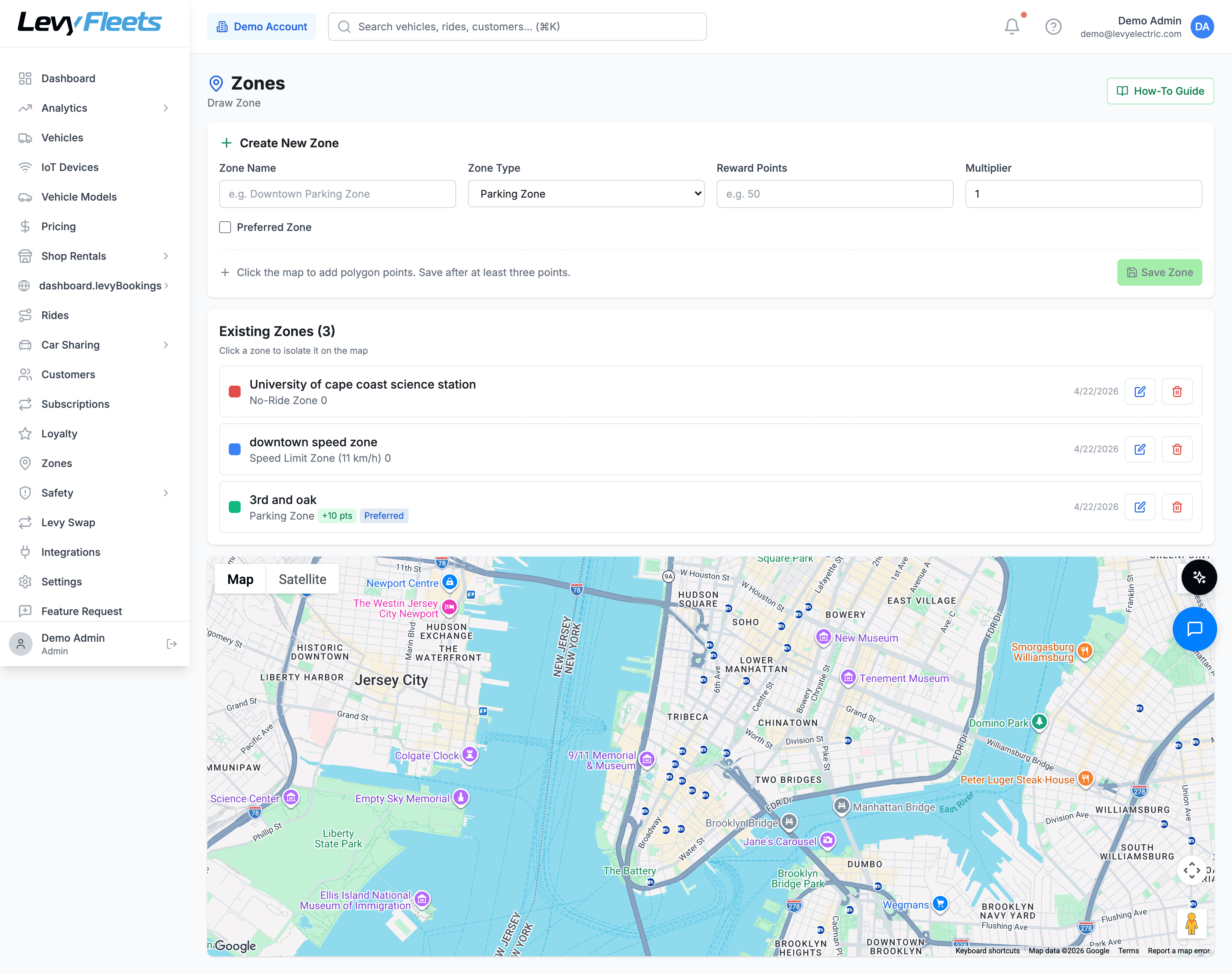
Levy zones handle four jobs, and you will use all four on almost every deployment. The zones configuration guide in your help center covers geofencing zones for service areas, parking, no-go areas, and speed limits. Real-time GPS, remote lock and unlock, speed monitoring, and geofencing are standard on every connected vehicle, so each of these zones is enforced live while the ride is in progress, not reconstructed after the fact.
| Zone type | What it does | Primary tradeoff it controls |
|---|---|---|
| Service area | Defines where rides can start and end | Coverage vs rebalancing cost |
| No-go zone | Blocks riding or parking inside a boundary | Compliance vs rider friction |
| Slow zone | Caps top speed inside a boundary | Safety and compliance vs ride quality |
| Parking zone | Marks approved end-of-ride spots, with optional rewards | Sidewalk clutter vs rebalancing cost |
Service area (your operating boundary)
The service area is the outer fence: riders can only unlock, ride, and end trips inside it. This zone decides your addressable market and your labor cost at the same time. A large service area captures more trip requests, but every square block you add is ground your team has to rebalance, swap batteries in, and recover stranded vehicles across.
A useful launch rule: draw a service area your team can fully rebalance in a single 4 to 6 hour shift with the headcount you actually have on payroll, not the headcount you hope to hire. It is far better to saturate a tight core with reliable availability than to thin your fleet across a sprawling zone where riders open the app and see no vehicle within a 10 minute walk.
No-go zones (no-ride and no-park)
No-go zones carve exclusions out of your service area: private campuses, highways, transit platforms, parks that ban riding, or a downtown block the city wants kept clear. Levy enforces these in real time, so when a rider approaches or enters the boundary the vehicle responds during the ride rather than after it. You can require riders to move a vehicle back into a valid area before they can end and lock the trip, which is how you keep no-go zones from filling up with abandoned vehicles.
Do not over-carve your map
Every no-go zone you add is a place a rider can get stuck and a support ticket waiting to happen. Start with only the exclusions the city mandates or that create genuine safety or trespass risk. Add more later based on where vehicles actually pile up, not on a theoretical worst case. An over-restricted map trains riders that trips fail near your best corridors.
Slow zones (speed-limit zones)
Slow zones cap a vehicle's top speed inside a boundary without banning riding entirely. Use them where you want throughput but not full speed: crowded plazas, boardwalks, campus quads, dense retail strips, and shared paths. Levy applies the cap in real time the moment the vehicle crosses the boundary, so the rider physically cannot exceed the limit inside the zone regardless of how hard they hold the throttle.
Slow zones are your compromise tool. When a city or property manager pushes to ban riding somewhere, a slow zone often satisfies the real concern (speed near pedestrians) while preserving coverage a hard no-go zone would destroy. Reach for a slow zone before a no-go zone.
Parking zones and parking rewards
Parking zones mark the approved spots where a ride can end. Two paths exist, and the choice drives both your compliance posture and your rebalancing bill. You can leave parking free-floating (end anywhere inside the service area that is not a no-go zone) or require riders to end inside defined parking zones. Levy also supports parking rewards: a small credit that nudges riders to end at the racks and corrals you actually want filled.
At end of ride, Levy Vision validates the parking photo the rider submits. The parking classifier checks exactly four things: is the vehicle upright, is it inside the parking zone, is it blocking the sidewalk, and is the photo clear enough to judge. That check is what turns a parking zone from a line on a map into an enforced behavior, and it is a parking-compliance step only, not a damage or condition inspection.
Use rewards before mandates
A parking reward that concentrates vehicles at a handful of high-demand corrals can cut your rebalancing distance more than a strict parking mandate, and it does it without the rider friction of a blocked ride-end. Try rewards first. Reserve mandatory parking zones for the specific blocks where the city requires them or where sidewalk clutter is generating complaints.
Coverage versus rebalancing cost: the math behind the map
Every zone edit moves money in one of two directions. Widening coverage or loosening parking adds potential rides but spreads vehicles thinner and lengthens the routes your team drives to reset them. Tightening coverage or concentrating parking cuts labor but forfeits trips at the margin. Your job at launch is to find the smallest, densest footprint that still gives riders reliable availability, then expand as demand proves out.
Think in three numbers as you draw:
- Serviceable density. Enough vehicles per block that a rider opening the app almost always sees one within a short walk. Thin availability kills repeat usage faster than almost anything else.
- Rebalancing radius. The real distance a technician drives to move a vehicle from where it dies to where it earns. Every no-go zone and free-floating parking allowance stretches this radius.
- Compliance headroom. The gap between what your zones enforce and what your city permits. Keep a cushion, because closing that gap after a complaint costs far more than building it in up front.
When these three fight, resolve in favor of density and compliance first. Coverage you cannot service is a liability, not an asset.
The specific thresholds here (a 4 to 6 hour rebalance shift, a vehicle within a short walk, the right service-area size) are planning heuristics, not fixed rules. Serviceable density, rebalancing radius, and profitable footprint all vary by city, season, vehicle mix, and how hard you run the fleet, so your numbers will differ. Model your own market in the Fleet Estimator before you commit headcount to a footprint.
Draw your service area in the right order
Sequence matters. Draw the layers in the wrong order and you will spend launch week patching holes riders already fell through.
Start from demand, not from the city limits
Center your service area on the corridors where trips will actually originate: transit stops, campuses, nightlife strips, waterfronts, retail cores. Do not default to the full municipal boundary. A tight, demand-shaped zone almost always outperforms a wide administrative one.
Trace the outer service boundary you can service
Draw the operating fence around the area your team can rebalance in one 4 to 6 hour shift. Leave a block or two of buffer inside any hard edge so a rider drifting toward the boundary is warned before the ride is blocked.
Subtract the mandated no-go zones
Carve out only the exclusions the city requires or that create real safety or trespass risk (highways, transit platforms, ride-banned parks). Resist adding speculative ones.
Add slow zones where speed is the real concern
Wherever you were tempted to ban riding but the actual issue is pedestrians, place a slow zone instead. You keep the coverage and satisfy the safety concern.
Place parking zones and turn on rewards
Define approved parking at your highest-demand nodes first. Turn on parking rewards to pull vehicles toward the corrals you want filled before you consider making any of them mandatory.
Pressure-test the overlaps
Where zones stack (a slow zone inside the service area, a parking zone next to a no-go edge), confirm the rules resolve the way you expect. Levy applies stacked-geofence priority so the most restrictive rule wins where boundaries overlap, which is the safe default for compliance.
Parking model: free-floating, hubs, or mandatory zones
Your parking model is the highest-leverage single choice on the map because it drives sidewalk complaints and rebalancing cost simultaneously. The three common models sit on a spectrum from most rider convenience to least operations cost.
- Free-floating. Riders end anywhere legal inside the service area. Maximum convenience and trip completion, maximum sidewalk-clutter and rebalancing exposure. Levy Vision still validates each parking photo, so free-floating does not mean unmonitored.
- Reward-nudged hubs. Free-floating by default, but parking rewards pull riders toward preferred corrals. This is the sweet spot for most launches: you keep convenience while steering the majority of ride-ends to spots that shrink your rebalancing radius.
- Mandatory parking zones. Rides can only end inside defined zones. Lowest sidewalk risk and tightest vehicle clustering, at the cost of blocked ride-ends and rider friction when a corral is full or far.
Which model fits depends on your city's rules and your vehicle mix. For a deeper comparison of the operating and unit-economic differences, read our breakdown of free-floating versus docked scooter models.
Keep the city happy: compliance geofences, MDS, and GBFS
Your zone map is also a regulatory document. Many cities require operators to publish real-time data feeds and to enforce geofences on demand, and losing a permit costs far more than any rebalancing inefficiency. Levy's city-compliance layer supports MDS 2.0 provider feeds, GBFS 3.0 feeds, and city policy ingestion, with real-time geofence and speed enforcement so the rules you draw are the rules the city sees enforced.
Build compliance headroom into the map
When a city hands you a required no-ride or slow area, implement it exactly and then leave yourself margin. If the mandate is a speed cap, a slow zone is usually enough. If it is a hard ban, use a no-go zone. Because Levy resolves overlapping zones by stacked-geofence priority (most restrictive rule wins), you can safely layer a city mandate on top of your own operating zones without them fighting.
One nuance worth planning for: geofences enforce location and speed, but they cannot by themselves tell whether a rider is on the roadway or the sidewalk in an area where riding is allowed. Levy Vision's sidewalk detection with throttle-cut enforcement is the complementary layer for that specific problem. Use geofences for where riding is permitted and how fast, and treat sidewalk detection as the separate tool for riding-surface compliance.
Let demand data size your zones and cut rebalancing
Your first map is a hypothesis. The data tells you whether it was right. Levy's AI Ops add-on forecasts demand per H3 hex over 1, 4, or 24 hour horizons conditioned on weather and events, and it produces ROI-ranked rebalancing recommendations in the form "move N vehicles from hex A to hex B by time T, projected lift $X." It can also route battery swaps and rebalancing together in the operator app so one technician trip does double duty.
Two things AI Ops does not do, and you should design around both. It recommends and forecasts, but it does not auto-execute moves: a human still approves and dispatches. And it is not dynamic or surge pricing; the smallest bucket is one hour, so treat it as planning intelligence, not a real-time pricing engine. Used well, the forecasts tell you where to expand a service area boundary, where a slow zone is throttling real demand, and which parking hubs to reward more aggressively to shorten your recovery routes.
Review cadence and common mistakes
Zones are not set-and-forget. Review performance every 2 to 4 weeks for the first quarter, then monthly once the map stabilizes. Look at where rides fail to start or end, where vehicles pile up unridden, and where your rebalancing routes run longest. Each of those is a zone edit waiting to happen.
The operators who win at launch treat the zone map as a living operations tool: tight to start, compliant by design, and continuously reshaped by where rides and vehicles actually go. Get the first map close, then let the data pay you back in shorter routes and higher availability.
See zone setup in the Levy dashboard
Book a walkthrough and we will map your launch city with you: service area, no-go and slow zones, and a parking strategy tuned to your rebalancing budget.